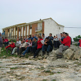
 About 40 adults and about 8 children participated in the First Geological Map by Areas of San Juan, Moratalla. The day was cloudy but warm, ideal for walking in the field without sweating too much. The excellent atmosphere and explanations of Carlos and the behavior of participants. Learn "live" Geology is an experience I recommend to anyone. It was a joy, now see with new eyes, deeper valleys and mountains of San Juan Campos and vicinity. I invite you to write reviews, especially those who attend the march.
  The "Norbet Strait, about 15 million years.
  View from the Sabine. To the right of the Jurassic limestone relief "Subbetica, driven north, strongly folded and eroded emerged, which contributed sediment to close Norbet. These sediments, transformed into rocks on the left of the picture, forming the reliefs "prebetic" Sierra de Motor Zaen Caves.
  Stops along the tour.
 Greetings: Carlos
In the next album I've posted some photos of the geological map we made the last weekend. Click on it to see them.
 |
| 09/05/2009 geologic map Moratalla (Murcia, Spain) |
0 comments:
Post a Comment